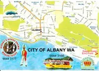
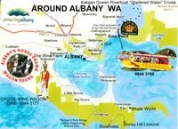
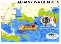
Albany Maps: Maps of Albany WA, Print out Free Maps, Perth to Albany Western Australia. Valid 2017 till 2018.
Albany Australia Free Maps
I hope you find these Albany Australia Maps useful, when you first come to Albany WA it can be hard to find what to see and where to go. So these are not just Albany Western Australia Maps but they have information on them. If you download the Albany Beaches map you can cross reference with our Albany Beaches information page.
click on map to download PDF - (high quality files, please be patient)

History of Maps
Road Maps - Cartography or Map making
Survey Maps - Worlds Oldest Map
Cartography or map-making is the study, and often practice of crafting representations of the Earth upon a flat surface and one who makes maps is called a cartographer.
Road maps are perhaps the most widely used maps today, and form a subset of navigational maps, which also include aeronautical and Nautical Charts railroad maps network maps, and hiking and bicycling maps.
In terms of quantity, the largest number of drawn map sheets is probably made up by local surveys, carried out by municipalities, utilities, tax assessors, emergency services providers, and other local agencies.
Many national surveying projects have been carried out by the military, such as the British Ordnance survey maps (now a civilian government agency internationally renowned for its comprehensively detailed work).
In addition to location information maps may also be used to portray contour lines (isoclines) indicating constant values of elevation, topography, rainfall, temperature etc.
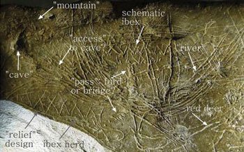
Worlds Oldest Map
Archaeologists have discovered what they believe is man's earliest map, dating from almost 14,000 years ago Photo: EPA
Archaeologists have discovered what they believe is man's earliest map, dating from almost 14,000 years ago Photo: EPA
A stone tablet found in a cave in Abauntz in the Navarra region of northern Spain is believed to contain the earliest known representation of a landscape.
Engravings on the stone, which measures less than seven inches by five inches, and is less than an inch thick, appear to depict mountains, meandering rivers and areas of good foraging and hunting
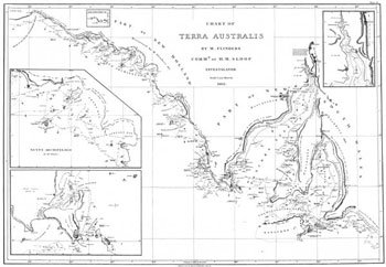
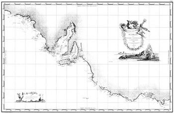
Australia ’s First Map
First map of Australia from Nicholas Vallard's atlas, 1547, in the Library of Sir Thomas Phillipps, Bart. At Middle Hill, 1856 [cartographic material].
Albany's Riverboat Kalgan Queen Scenic Cruises
45593 South Coast Hw, Kalgan WA 6330
Australia 08 9844 3166