Oyster Harbour and Emu Point
Oyster Harbour is the most sheltered Harbour in Albany which is near Emu Point. This is where Kalgan Queen Riverboat, tours, cruises and Albany WA Australia. The Harbour is good for fishing, bird watching and wildlife and also home to one of only four places where Pelicans breed in WA.
The Kalgan River
The Kalgan River which flows into Oyster Harbour is one of the oldest Rivers in the World and home to the Kalgan Queen Riverboat. Many people believe its scenic beauty and wildlife far exceed the French Riviere des Fancaise after which it was named in 1803 by the French explorer, Nicholas Baudin.During the late nineteenth and early twentieth century’s the Albany served as a gateway to the Eastern Goldfields and for many years was Western Australia’s only deep water port, making it a place of importance for shipping services between the UK and its Australian colonies. The construction of Fremantle Harbour in 1893 saw its importance as a port decline. After which Albany industries turned primarily to agriculture and timber and, later, whaling and tourisum. Unlike Perth and Fremantle WA, Albany was a strong supporter of Federation in 1901.
Albany Australia home to ANZAC
The memorial to the Desert Mounted Corps is on top of Mount Clarence. The memorial consists of a statue of an Australian mounted soldier helping a New Zealand soldier whose horse has been wounded. There is a wall bearing the words "Lest We Forget". A dawn service was started in Albany Australia by a Church of England Priest Called the Reverend Arthur White Today several thousand people participate in this service each year.
In Herberton Nth Queensland there is a grave just marked. A Priest. Next to the grave a marker which reads, quote: - Adjacent to, and on the right of this marker, lies the grave of the late Reverend Arthur Ernest White, a Church of England clergyman and padre, 44th Battalion, First Australian Imperial Force.
On 25th April 1923, at Albany in Western Australia, the Reverend White led a party of friends in what was the first ever observance of a Dawn parade on ANZAC Day, thus establishing a tradition which has endured, Australia wide ever since.
Albany Australia Geography & Beaches
Middleton Beach, Albany Australia: The city centre of Albany is located between the hills of Mount Melville and Mount Clarence, which look down into Princess Royal Harbour. There are many beaches surrounding Albany which are great attractions, with Middleton Beach being the closest to the town centre. Popular beaches include Middleton Beach, Frenchman's Bay and Muttonbird Island. It is 408 kilometres (254 miles] south-southeast of the state capital, Perth, to which it is linked by the Albany Highway and the Highway 1 (a less direct but more scenic route).
Albany WA Industry
The main industries of Albany WA consist of tourism, fishing and agriculture; although before the 1950s whaling was one of the major sources of income and employment for the population. The Whaling Station, which closed operations in 1979, has now been converted to a museum of whaling, and features one of the 'Cheynes' whale chasers that were used for whaling in Albany. The station was the last operating whaling station in the Southern Hemisphere at the time of closing.
Albany WA also has a number of historic tourist sites including the Museum, Albany Convict Gaol, The Princess Royal Fortress (commonly known as The Forts), Patrick Taylor Cottage, and ("is the oldest dwelling in Western Australia, c1832"). Albany has a great deal of historical significance to Western Australia.
Natural sights and attractions are also numerous, especially the rugged coast which includes the Natural Bridge and the Gap. The beaches have pristine white sand. The destroyer HMAS Perth was sunk in King George Sound in 2001 as a dive wreck Albany is also close to two mountain ranges, the Porongurup’s and Stirling Ranges.
Albany Australia is also the southern terminus of the Bibbulmun Track walking trail in WA. Which is one of the great attractions.[ Albany is home to HMAS Albany (based in Darwin) and the adopted home port of the Royal Australian Navy frigate HMAS Anzac. Other warships frequently visit Albany.
Albany is a subregion of the Great Southern region of Western Australia its focal point being the town of the same name. Albany’s climate is maritime, strongly shaped and moderated by the Southern Ocean; the standard description is that it is Mediterranean, with moist, cool winters and warm, dry summers.
Diurnal temperature range is minimal and moderate humidity in summer assists ripening by reducing stress on the vines. Soil conditions: lateritic gravelly, sandy loams or sandy loams derived directly from granite and gneissic rocks.
Lat: 35 02’S; Alt: 75 m; Hdd: 1495; Gsr: 303 mm; Mjt: 19C; Harvest: Early Mid-March to end April; Chief Viticultural Hazard: Birds.
Western Australia
Western Australia is a state of Australia, occupying the entire western third of the Australian continent. Australia’s largest state Western Australia and the second largest subnational entity in the world, it has 2.2 million inhabitants (10% of the national total), 85% of whom live in the southwest corner of the state.
The state's capital city is Perth. The people of WA are often colloquially referred to as sandgropers, the common name of an insect found on sand dunes around Perth WA.
Geography of Western Australia
WA is bounded by South Australia and the Northern Territory to the east, and the Indian Ocean to the west and north. In Australia, the body of water south of the continent is officially gazetted as the Southern Ocean, whereas the International Hydro graphic Organization (IHO) designates it as part of the Indian Ocean.
The total distance of the state's eastern borders is 1,862 km, and there is 12,889 km of coastline. The total land area occupied by the state is 2.5 million km 2 Natural history
Climate
The southwest coastal area of WA has a Mediterranean climate and was originally heavily forested, including large stands of the karri, one of the tallest trees in the world. This agricultural region of WA is in the top nine terrestrial habitats for terrestrial biodiversity, with a higher proportion of endemic species than most other equivalent regions. Thanks to the offshore Leeuwin Current the area numbers in the top six regions for marine biodiversity, containing the most southerly coral reefs in the world.
Average annual in rainfall in WA varies from 300 millimetres (12 in) at the edge of the Wheatbelt region to 1,400 millimetres (55 in) in the wettest areas near Northcliffe , WA , but in the months of November to March evaporation exceeds rainfall, and it is generally very dry. Plants must be adapted to this as well as the extreme poverty of all soils. A major reduction in winter rainfall has been observed since the mid-1970s, with a greater number of extreme rainfall events in the summer months.
The central four-fifths of the state is semiarid or desert and is lightly inhabited with the only significant activity being mining. Annual rainfall averages 200–250 millimetres (8–10 in), most of which occurs in sporadic torrential falls related to cyclone events in summer months.
An exception to this is the northern tropical regions of WA. The Kimberley , WA has an extremely hot monsoonal climate with average annual rainfall ranging from 500 to 1,500 millimetres (20–60 in), but there is a very long almost rainless season from April to November. Eighty-five percent of the state's runoff occurs in the Kimberley Western Australia , but because it occurs in violent floods and because of the insurmountable poverty of the generally shallow soils, the only development has taken place along the Ord River.
The highest observed maximum temperature of 50.5 °C (122.9 °F) was recorded at Mardie, Pilbara, 61.6 kilometres (38.3 mi) from Barrow Island on 19 February 1998 . The lowest minimum temperature recorded was -7.2 °C (19.0 °F) at Eyre Bird Observatory on 17 August 2008 .
Biota
540 species of birds including the Long Beaked Black Cockatoo Baudin. Of these around 15 are endemic to the state. The best areas for birds are the southwestern corner of the state and the area around Broome and the Kimberley.
The Flora of WA, comprises 9437 published native vascular plant species of 1543 genera within 226 families, there are also 1171 naturalised alien or invasive plant species more commonly known as weeds. In the south west region are some of the largest numbers of plant species for its area in the world.
William Henry Harvey published a five-volume Phycologia Australia, which was issued in parts between 1858 and 1863. He earned the title of father of Australian Phycology. His main collection is in the herbarium of Trinity College Dublin; there is also a large collection of his specimens in the Ulster Museum, Belfast.
History of and Aboriginal history of WA.
The first inhabitants of Australia arrived from the north approximately 40,000 to 60,000 years ago. Over thousands of years they eventually spread across the whole landmass. These Indigenous Australians were well established throughout WA by the time of European explorers began to arrive in the early seventeenth century.
The first European to visit WA was a Dutch explorer, Dirk Hartog who on 26 October 1616 landed at what is now known as Cape Inscription, Dirk Harthog Island. For the rest of the 17th century, many other Dutch travellers enountered the coast, usually unintentionally. By the late 18th century, British and French sailors had begun to explore the WA coast.
The origins of the present state of WA began with the establishment of a British settlement at King George Sound in 1826 (later named Albany from 1832). The settlement was founded in response to British concerns about the possibility of a French colony being established on the coast of WA.
In 1829, Captain James Stirling established the Swan River Colony, on the Swan River, WA. By 1832, the British settler population of the colony had reached around 1,500. The two separate townsites of the colony developed slowly into the port city of Fremantle and the state's capital, Perth WA.
Population growth was very slow until significant discoveries of gold were made in the 1890s around Kalgoorlie , WA .
In 1887, a new constitution was drafted, providing for the right of self-governance and in 1890, the act granting self-government to the colony was passed by the British House of Commons. John Forrest became the first Premier of Western Australia. [WA]
In 1896, the WA Parliment authorised the raising of a loan to construct a pipeline to transport five million gallons of water per day to the goldfields of WA. The pipeline, known as the Goldfields Water Supply Scheme, was completed in 1903. C.Y. O'Connor, Western Australia 's first engineer-in-chief, designed and oversaw the construction of the pipeline. It carries water 530 km (330 miles) from |Perth to Kalgoorlie , WA and is attributed by historians as an important factor driving the state's population and economic growth.
Following a campaign led by Forrest, residents of the Swan River Colony voted in favour of federation, resulting in WA officially becoming a state on 1 January 1901.
Demographics of Western Australia
The first inhabitants of what is now WA were Indigenous Australians, from a wide variety of language and kin groups—for example, the Nyungah in the south west, the Wongai in the central desert, the Malkana in Shark Bay. These groups continue to form the majority of the local population in the remotest parts of the state such as the Kimberley, WA.
Europeans began to settle permanently in 1826 when Albany was claimed by Britain in order to forestall French claims to the western third of the continent. Perth was founded as the Swan River Colony in 1829 by British and Irish settlers, though the outpost languished, eventually requesting convict labour to augment its population. In the 1890s, interstate migration resulting from a mining boom in the Goldfields region resulted in a sharp population increase.
Western Australia did not receive significant flows of migrants from Britain , Ireland or elsewhere in the British Empire until the early 20th century when local projects. Such as the Group Settlement Scheme of the 1920s which encouraged farmers to settle the southwest increased awareness of WA third as a destination for colonists.
Led by migrants from the British Isles , Western Australia 's population developed at a faster rate during the twentieth century it had previously. Along with the eastern states, Western Australia received large numbers of Italians, Croatians and Greeks after World War II. Despite this, Britain has contributed the greatest number of migrants to this day, and [WA] particularly Perth [WA] has the highest proportion of British-born of any state: 10.6% in 2006, compared to a national average of 5.3%. This group is heavily concentrated in certain parts where they account for a quarter of the population. Including Jonathan
Welcome to the Albany West Australia History Photo Tour .
The meaning of Towns and places ending in up.
Welcome to the Albany Australia History pages. Albany was founded as the first white settlement in 1826 when a Major Edmond Lockyer arrived in the Brig Amity. He noticed a fire on Michaelmas Island as he sailed in. It turned out later that four Aboriginal men had been abandoned there by American Whalers.
The crew rescued them the next day, Boxing Day. Then on the 21 st of January 1827 Major Lockyer declared that Fredericks Town named after King Georges Brother Fred was part of the Kings realm. So we were not always known as Albany. Which is, despite some other claims, the first white settlement in Western Australia, of course Aboriginal people had been here for many thousands of years.
The local Aboriginals were Minang Noongar and they called this area Kinjarling, which means “The place of rain”.
So what’s up? Up is found at the end of many Town names such as, Dwellingup, Kojonup, or Ongerup to name just a few. Dwellingup is place of nearby water, Kojonup is place of the South West stone axe, Kadjo and the stone used to make it, Kadjor. Another less likely meaning is place of the edible bulb. But of course it could be place of both of them!
Ongerup is place of the “Yonger” which is the Aboriginal word for the male Kangaroo, so Ongerup is place of the male Kangaroo. Some of the up names are lost in history As there are more than 50 towns whose name ends in up, we have made a special listing with much more detail.
Just press the, “What’s up in West Australia” button. You may want to look up the meaning of names of Towns you have been to, or the ones you are going to visit. You will notice these places have water, hence the early settlers misunderstanding that up is “place of water” rather than “place of”.
It is mentioned in the early explorer records or journals that the local Aboriginals did not swim or have boats. The assumption was and is that there were to many Sharks. It was also noted that they would not go much deeper than knee deep! Can’t say as I blame them.
The first European explorers to visit the area around Albany were on the Dutch ship, Gulden Zeepaert, or Golden Seahorse. Francois Thijssen skippered this in 1626.
George Vancover on behalf of the British explored the South coast in 1791. Naming many local places, which include, Michaelmas Island, Breaksea Island, King George the Third Sound, Princes Royal Charlotte Harbour and Oyster Harbour, to name a few. As a result of his visit Green Island, Swan Point and Point Possession were named.
Matthew Flinders arrived in King George Sound in 1801, however back then it was known as King George the Third Sound. As was Princess Royal Harbour known as “The Princess Royal Charlotte Harbour, named after King Georges Favourite daughter. The Princess Royal, Charlotte Augusta Matilda.
Nicholas Baudin a French explorer arrived in 1803 on board the Geographe with Louis Freycinet on the Casurania. Baudin was the first man to explore the Kalgan River in a boat in fact he named it: The Riviere De Francis, a name, which lasted 30 years.
Captain Kalgan arrived in Albany with Jack and Dolly Damper maker in February 1998. However you can find out this and much more on “The Kalgan Queen” or “Albany Horse Drawn Wagon Tours”.
The secret ingredient is Naturally soured milk, leave the top on and leave it at room temperature until it sours, the more the better. Well found! But now that’s History.
The photos on the history page are,
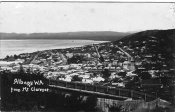
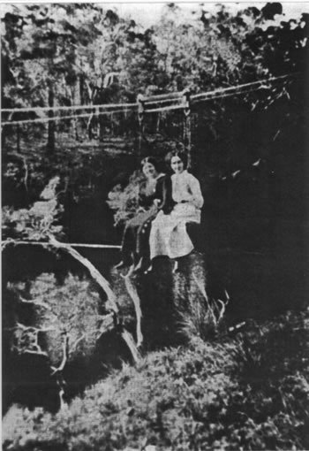
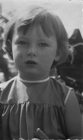
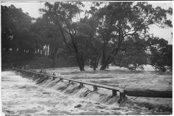
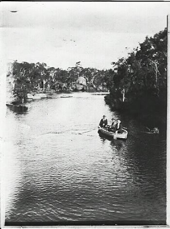
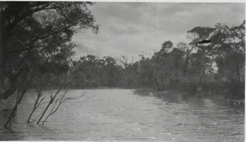
Albany from Mount Clarence, Candyup Jetty, Captain Kalgans Little Girl. Aboriginal Rock fish traps possibly 19000 years old, flooding on the Kalgan 1939.
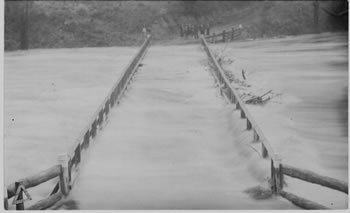
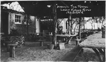
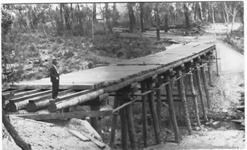
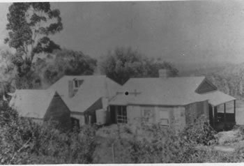
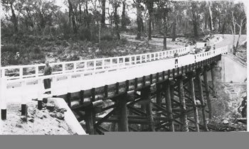
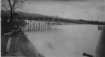
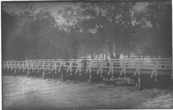
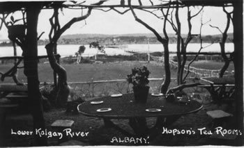
Flying fox over the Kalgan River, Hopson’s Tearooms Shellgrit tablecloth, Hopson’s Tearooms, Kalgan floods. Lower Kalgan Bridge 1912, New Upper Kalgan bridge 1940.
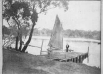
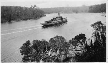
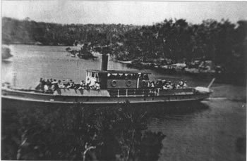
Patrick Taylors Candyup, River in Flood. Rowing on the River. Sam and Captain Kalgan. Silver Star at Elbow Island now better known as Honeymoon Island, Silver Star on the Kalgan River.
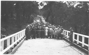
Upper Kalgan Bridge construction 1939/1940. Kalgan Flooding 1939 and the Kalgan bridge opening in 1940.
The secret ingredient is Naturally soured milk, leave the top on and leave it at room temperature until it sours, the more the better. Well found! But now that’s History.
The meaning of Towns and Places
ending in "UP" in Western Australia.
What up means, at the end of names.
What’s up in Western Australia.
Aboriginal meanings of up. Up means place of, not water.
ALBANY MEANING
Latitude 35° 02’ Longitude 117° 54’
The City of Albany, located on the south coast of Western Australia , was officially named by Governor Stirling at the beginning of 1832. It is named after Frederick, the Duke of Albany and York, and the favourite son of King George III. The city is located on King George Sound , which was discovered and named "King George the Third's Sound" on 28th September 1791 , by Captain Vancouver.
Albany was the site of the first settlement in WA when Major Edmund Lockier of the 57th Regiment, under instructions from the N.S.W. Govt. hoisted the British Flag on 21.1.1827 on the site of "The Residency".
The city was more often referred to as King George Sound or King George's Sound for about the first 40 years of settlement. Portion of it was originally named "Fredrickstown" by Major Lockyer in 1827 in honour of the Duke of York and Albany, Commander in Chief of the British Army. This name disappeared about 1831 and the name Albany was retained for the whole town.
BADGEBUP MEANING
Latitude 33° 38’ Longitude 117° 54’
A townsite between Katanning and Nyabing, this place was originally proposed as "Badjebupp", for the name of a station on the Katanning - Nampupp (Now Nyabing) Railway in 1910. The name is derived from nearby Badgebup Well, and is an Aboriginal word said to mean, "place of wild rushes". Another source gives it as "broad green leaves on a plant round soak".
The Townsite was gazetted as Badjebup in, changed to "Nalabup" in 1923, changed back to "Badjebup" in 1923, and finally to Badgebup in 1972.
BALBARRUP MEANING
Latitude 34° 14’ Longitude 116° 12’
This townsite, located near Manjimup, was originally gazetted as "Manjimupp" in 1903. The name was changed to Balbarrup in 1910 to avoid confusion with the new townsite of "Manjimupp" (later Manjimup) situated on the railway about 5km further west. Balbarrup is the Aboriginal name of a nearby brook and place first recorded by a surveyor in 1863, but the meaning of the name is not known.
BALINGUP MEANING
Latitude 33° 47’ Longitude 115° 59’
The townsite of Balingup is located in the south west, 241 km south of Perth and 31 km south east of Donnybrook. The townsite takes its name from Balingup Pool, located in Balingup Brook, which flows through the town. The name was first recorded by a surveyor in 1850, and is said to be derived from the name of an Aboriginal warrior, Balingan.
Balingup is located on the South Western Highway , the main road south to Bridgetown and beyond. It was gazetted as a main road in 1872, and by this time there were a number of farms in the area. In the 1860s the poet Adam Lindsay Gordon was one who had a large flock of sheep here. In the mid 1890s the government planned a railway from Donnybrook to Bridgetown , and Balingup was selected as the site of one of the stations. The government also decided it would establish a townsite at Balingup, but the land at the selected site was privately owned. This land was purchased in 1896, and a scheme of subdivision promptly approved, and lots surveyed in 1897. The townsite was gazetted in 1898, the same year the railway was opened.
BINNINGUP MEANING
Latitude 33° 09’ Longitude 115° 41’
Binningup is a south western coastal townsite located 153 km south of Perth and 27 km north of Bunbury. Binningup takes its name from "Binningup Beach Estate", a name used by a syndicate of Harvey people who subdivided the area in 1953. It is apparently an Aboriginal name, but not necessarily traditional. By 1962 there was only one resident in the area, but many homes were built in the following few years. At the request of the Shire of Harvey Binningup was gazetted a townsite in 1963.
BOYANUP MEANING
Latitude 33° 29’ Longitude 115° 44’
The townsite of Boyanup is located in the south west agricultural region, 195 km south of Perth and 18 km south east of Bunbury. In 1888 a railway was built between Boyanup and Bunbury, and in 1891 the government opened up land in the area by declaring the Boyanup Agricultural Area. Land was set aside for a townsite in the agricultural area, lots in the townsite surveyed in 1893, and the townsite gazetted in 1894.
Boyanup is an Aboriginal name, having been first recorded by an explorer in 1852. It is also on the main road south, and is shown on a road survey in 1869 as Boyinup. It is said to mean "a place of quartz" - Boya means "rock" or "stone".
BOYUP BROOK MEANS
Latitude 33° 50’ Longitude 116° 21’
The townsite of Boyup Brook is located in the great southern agricultural region, 269 km south south east of Perth and 31 km north east of Bridgetown. The Boyup Brook area was known as Upper Blackwood when in 1896 the government set land aside for a future townsite on the Blackwood River about 8 km south of the present townsite. In 1899 farmers in the area met and formed the "Upper Blackwood Progress Committee", and wrote to the government requesting the setting aside of a townsite in which to erect a school, places of worship and other public purposes. The Committee was seeking to "advance the interests of this rising and important district".
The request for a townsite shrewdly proposed it be named "Throssell". It was addressed to the Minister for Lands, at that time George Throssell. The Lands Department resisted the proposal at first, as it did not consider there was enough demand for lots, but the Progress Committee persisted, and the Minister directed the Department to survey some lots. The survey was carried out in 1899 and although the name Throssell was used for a short time, Sir James Lee Steere, former resident of the area and prominent politician, suggested the Aboriginal name Boyup, by the which the area was locally known, should be used. The townsite was gazetted as Boyup in 1900, although local usage was mostly "Boyup Brook". In 1908 there was a major expansion of the townsite, and locals suggested that as there was some confusion with the similarity of Boyup and Boyanup, the townsite should be renamed Boyup Brook. The renaming was approved, and the townsite regazetted as Boyup Brook in 1909.
The name is derived from the Aboriginal name of a nearby watercourse, Boyup Brook, which was first recorded as Booyup Brook in 1877. Buyu is said to mean "place of smoke", and another account states that "Booy" means "big smoke", and was named because the brook was originally surrounded by blackboys which, when set alight, sent up a cloud of black smoke.
BUREKUP MEANING
Latitude 33° 19’ Longitude 115° 48’
Burekup is a townsite located in the south west, east of Bunbury. In 1910 the Railways Department requested to name a new siding on the Pinjarra-Picton line as "Boorekup", stating this was "the Aboriginal name of a wildflower that grows profusely in the locality".
The spelling was altered to Burekup according to the rules of orthography used by the Department of Lands & Surveys, and the name was approved by the Minister for Lands in 1910. Land in the vicinity was privately owned, the first development of the area occurring in 1914. Burekup was gazetted a townsite in 1973, following a request from the Shire of Dardanup.
CHINOCUP MEANS
Latitude 33° 32' S Longitude 118° 23' E
The townsite of Chinocup was declared as "Chinokup" in 1923, to satisfy a need for blocks of land at the station of this name on the Nyabing-Pingrup Railway (now abandoned) The station was named after nearby Lake Chinocup, and the spelling of the townsite was changed in 1962 to agree with the lake. Chinocup is an Aboriginal word of unknown meaning, which had been recorded as the name of the lake in 1879.
CONDINGUP MEANING
Condingup is a townsite located in a wheat and sheep area near the south coast east of Esperance. It was declared a townsite in 1963, and takes its name from the nearby Condingup Peak . This is an Aboriginal name of unknown meaning, first recorded during surveys for the telegraph line in 1875/6.
COOKERNUP MEANS
Latitude 32° 59' S Longitude 115° 53' E
Cookernup is a town in the south west between Waroona and Harvey. A townsite was gazetted here in 1894, and derives its name from a farm established nearby by Joseph Logue in the early 1850's. Also spelt Kookernup in 1853, Logue Brook was once known as Cookernup Brook. The meaning of this Aboriginal name is given as "the place of the swamp hen"(cooki).
COOLUP MEANS
Latitude 32° 44' S Longitude 115° 52' E
Coolup is a town in the south west between Pinjarra and Waroona. It was gazetted a townsite in 1899, but the name has been recorded in the area since at least 1886. Coolup is an Aboriginal name possibly meaning "place of the wild turkey". (kool or koonlie are given as words for the wild turkey).
COOMALBIDGUP MEANING
Latitude 33° 38' S Longitude 121° 22' E
Coomalbidgup is a townsite on the South Coast Highway between Esperance and Ravensthorpe. It was gazetted in 1961, and takes its name from the nearby Coomalbidgup Creek. The name is Aboriginal, and one informant states it means "Possum scratches up a tree & there is water there". The explorer George Grey in 1839 recorded "Koo-mal" as meaning Possum, "up" means place, and Bid-dee or Bid-gee means waterhole in the dialect of the Mundrabilla Tribe.
COWARAMUP MEANING
Latitude 33° 51' S Longitude 115° 06' E
Located 12kms north of Margaret River , Cowaramup derives its name from Cowaramup Siding, which was located near the townsite, on the Busselton to Augusta railway. The townsite was gazetted in 1925, and the name is believed to be derived from "Cowara", the Aboriginal name for the Purple Crowned Lorikeet.
DALYUP MEANING
Latitude 33° 43' S Longitude 121° 36' E
Dalyup is a townsite on the South Coast Highway east of Esperance, about 700 kilometres from Perth . It was gazetted in 1962, and derives its name from the Dalyup River on which it is located. The name is Aboriginal, and possibly is the Noongar word for the King Parrot or Hookbill, spelt Djalyup" in some word lists.
The Dalyup River was discovered by the explorer J S Roe in 1848, and named by him " Gage River ". The first surveys in the area were carried out in 1875, and the surveyor, H S Carey recorded the Aboriginal name of the river as Dalyup. This name has taken precedence over Roe's name
DARDANUP MEANING
Latitude 33° 24' S Longitude 115° 45' E
Situated about 10 km south west of Bunbury, the Dardanup area was first settled by Thomas Little around 1852. Little built a homestead named "Dardanup Park", the name believed to be a variation of the Aboriginal word "Dudingup" the meaning of which is not known.
Little gave land to the Catholic Church and attracted other settlers to the area, and a small community soon developed.
Land at Dardanup was privately owned and developed, but in the 1920's the government acquired and subdivided land here for closer settlement. The townsite of Dardanup was gazetted in 1923.